Commercial drone capture for Greater London / South East England. CAA enhanced permissions, surveyor-led delivery, every project hosted on AIM Platform. From London city-centre roof inspections to estate-wide thermal surveys.
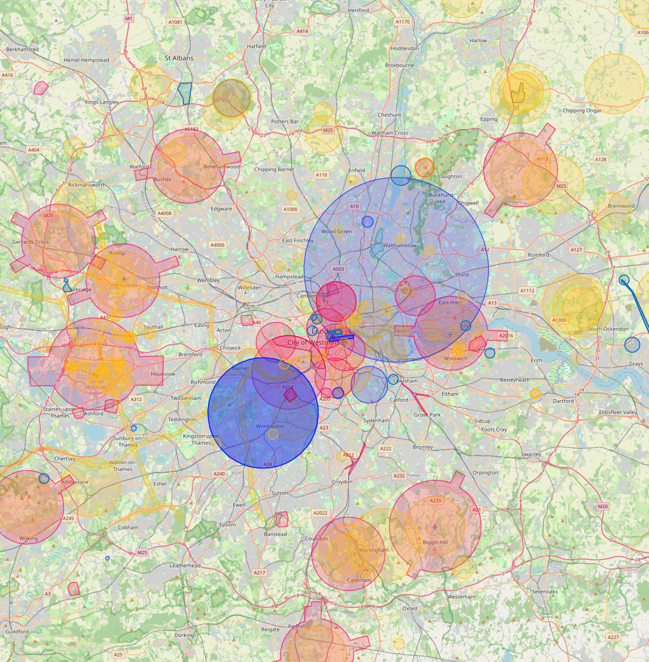
London is the most complex drone airspace in the UK. Heathrow CTR covers most of west London with 6km Flight Restriction Zones around Heathrow, Gatwick, Stansted, Luton and London City airports. Network Rail manages every mainline station; Met Police, Royal Parks and individual London boroughs each have their own filming and overflight processes. Most of central London also sits within Film London's licensing area.
Heathrow CTR5x airport FRZsNetwork RailRoyal ParksMet PoliceFilm London
Live airspace data from Altitude Angel via Drone Safety Map. Pan and zoom to explore restrictions around your site.
Where London clients send us
Common London project types.
Heritage estates, listed buildings, commercial property, mixed-use developments, infrastructure projects, insurance loss adjustment, Crossrail / HS2 corridors, prime residential.
Why London firms use us
Permissions that match the airspace.
London is the most complex drone airspace in the country. We hold the enhanced CAA permissions needed to fly closer to people and property than standard PDRA-01, plus the operational track record to coordinate with the Met, Network Rail and the Royal Parks for sensitive jobs.
Services in London
What we capture across the London area.
✓
Drone roof and gutter inspection Commercial and residential roof surveys, façade inspections, gutter checks, without scaffold or MEWP. Same-week scheduling.
✓
Thermal heat-loss and BREEAM surveys Calibrated thermal capture for retrofit planning, EPC support, and BREEAM compliance. Night-time and daytime where appropriate.
✓
Construction monitoring Monthly or weekly aerial capture for active construction sites. Time-series comparison hosted on AIM.
✓
Topographical and measured surveys Centimetre-grade ground capture, CAD drawings, Revit / BIM models, full 3D measured surveys for refurbishment and change-of-use.
✓
Confined space inspection Specialist drones for tank, tunnel, vessel and shaft inspection. No permit-to-enter, no shutdown.
✓
Drone media and 360 capture 4K and 8K drone video, Insta360 ground-level walk-throughs, FPV showcase content.
Local clients we work with
Public-sector and housing-association coverage.
Around London, our project pipeline regularly takes us across local authority and housing-association estates. We deliver scaffold-free roof inspections, retrofit thermography, condition surveys and BREEAM-grade thermal capture for organisations including:
Local authorities
✓GLA
✓City of London Corporation
✓Westminster
✓Camden
✓Islington
✓Hackney
✓Lambeth
✓Southwark
✓Tower Hamlets
Housing associations & estates
✓L&Q
✓Peabody Trust
✓Notting Hill Genesis
✓Clarion
✓A2Dominion
✓Network Homes
✓Catalyst
✓Optivo (Southern Housing)
Organisation names are common sector-active examples in the region. Specific client engagements are confirmed under NDA on request.
Permissions matter
Approved for business locations, airports, FRZs and restricted areas.
Most of the sites we're asked to fly, live commercial premises, near airports, inside Flight Restriction Zones, around Network Rail corridors, military air bases and Royal estates, require enhanced CAA permissions, prior notification, and an operator with the track record to coordinate with the relevant authority. We hold and operate under those permissions every day. If you've been told "no" elsewhere, our route to flying it is almost certainly already in place.
Every London project we capture is hosted on AIM Platform, the asset-information software used by surveyors, councils and contractors across the UK. Browser-streamable. Measurable in place. Shareable with one link.
Can you fly drones near London's controlled airspace?
Yes. We operate routinely under London City Airport CTR + Heathrow/Gatwick/Stansted/Luton approach paths. Our enhanced CAA permissions and notification procedures let us fly safely in and around controlled airspace where standard operators are restricted, including airport approach paths and Flight Restriction Zones.
Do you cover London central areas like City of London and Canary Wharf?
Yes. We routinely fly across London including City of London, Canary Wharf, West End, Stratford and Greenwich. Dense built-up areas, occupied commercial premises and live retail sites are all within scope under our enhanced CAA approval.
Can you fly drones near The Shard or other London landmarks?
Yes, where permitted. Iconic sites like The Shard sit within or near restricted areas, but we work with the landowner, the relevant authority and the CAA where needed to secure the right permissions. We have a strong track record of getting "no" sites to "yes".
How much does a drone survey in London cost?
Most commercial drone surveys in London range from £450 to £2,500 depending on site size, sensor type and turnaround. We quote firm within 24 hours of the brief, with no callout fees and no day-rate top-ups.
What does a typical drone survey deliverable look like in London?
You receive the captured imagery, measured outputs, and an interactive AIM Platform link for your team. London jobs are deliverable in the same browser-based viewer used for projects across the UK, no software install, no per-seat licences.
Do you survey housing portfolios across London?
Yes. Multi-property thermal and roof surveys for housing associations and social landlords in London are a routine workload. Reports are produced consistently across the entire portfolio in a single AIM Platform deliverable.
Quote a drone survey in London.
Tell us the site, the deliverable, and any access constraints. Most quotes turn around within 24 hours.